

Assessing the Impacts of Flooding on Environmental Sustainability and Livelihoods in Tonj Payam, Warrap State, South Sudan
Abstract
Introduction
Flooding is among the most destructive environmental hazards confronting communities in South Sudan. Beyond damaging infrastructure and property, floods disrupt livelihoods, degrade ecosystems, depress agricultural productivity, and deepen food insecurity.
A flood occurs when a river or other water body overflows its banks and submerges the surrounding land. The frequency and severity of extreme weather events have risen markedly in recent decades: weather-, climate-, and water-related hazards now account for around half of all recorded disasters and nearly half of reported disaster deaths worldwide (World Meteorological Organization [WMO], 2021). A flood becomes a hazard, rather than a routine natural process, only once it threatens human life or property (Smith & Petley, 2009), and flooding is now recognised as one of the most damaging climate-related hazards globally (WMO, 2008).
Floods also trigger outbreaks of waterborne disease, including cholera, typhoid, and hepatitis A, through contaminated drinking water (Few et al., 2004). Flood fatalities are commonly separated into immediate causes, such as drowning, trauma, heart attacks, fire, and electrocution (Jonkman & Kelman, 2005), and underlying causes, which include hazard, individual, environmental, socio-economic, and managerial factors (Yari et al., 2020). Elderly people, children, and people with disabilities are repeatedly identified as disproportionately vulnerable in disaster settings, reflecting intersecting social and physical disadvantages rather than age or disability alone (Kuran et al., 2020).
In Sub-Saharan Africa, recurrent flooding is closely tied to poverty: it destroys the very assets and livelihoods that households rely on to escape it, and the region is home to a disproportionate share of the world's flood-exposed poor (Rentschler et al., 2022). South Sudan is highly vulnerable to both flooding and drought. These shocks disrupt livelihoods and food security, drive displacement, and can intensify competition over natural resources, including cattle raiding and communal conflict.
Problem statement
Tonj South County in Warrap State faces mounting population pressure and fast-growing demand for land and pasture to sustain agro-pastoral livelihoods. Households in the county grow sorghum, groundnuts, beans, okra, maize, sesame, and pumpkin, and practise small-scale fishing on the Tonj River.
Food production and household income are constrained by prolonged, widespread flooding, which has caused extensive crop and livestock losses and destroyed houses and property. The area has flooded repeatedly over the past decade, including in 2014, 2015, 2016, and 2024, yet food production remains low and many households remain food insecure. Topography, river overflow, vegetation cover, soil type, and farming practices plausibly all contribute to this recurrent flooding, but their relative roles have not been documented for Tonj Payam specifically. This study therefore assessed the causes of flooding and its impacts on environmental sustainability and livelihoods in Tonj Payam, Tonj South County, Warrap State. Specifically, the article sought to:
- assess the causes of flooding in the study area;
- determine the impacts of flooding on the socio-economic activities of communities;
- explore the coping mechanisms used by communities and government to reduce the impacts of flooding; and;
- identify the groups most vulnerable to flooding.
Methods
Research design
The study used a cross-sectional, mixed-methods design combining a structured questionnaire with key informant interviews and focus group discussions. The questionnaire generated quantitative data on the extent of respondents' agreement with statements about the causes and impacts of flooding, allowing patterns to be quantified across a comparatively large sample. Interviews and focus group discussions generated qualitative data that contextualised and corroborated the quantitative results with residents' own accounts of their experience of flooding. This combination suited a topic in which both the scale of impact and the lived experience of affected households needed to be captured.
Description of the study area
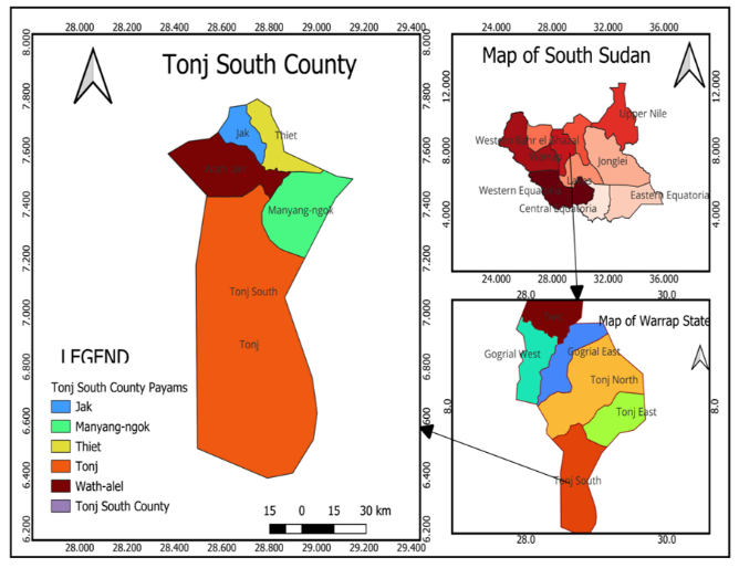
The study was conducted in Tonj Payam, Tonj South County, Warrap State, South Sudan. Tonj South County borders Gogrial East and Gogrial West Counties to the north, Tonj East County to the east, Tonj North County to the west, and Lakes and Western Bahr el Ghazal States to the south. The county is drained by the Tonj River, whose seasonal overflow, combined with flat terrain and clay-rich soils that drain poorly, predisposes the area to prolonged waterlogging during the rainy season.
The county's population depends predominantly on agro-pastoralism: households cultivate sorghum, groundnuts, maize, sesame, and vegetables, herd cattle and goats, and fish on the Tonj River. Household food security and income are therefore closely tied to the timing and severity of seasonal flooding.
Population
The target population comprised three groups considered best placed to provide first-hand information on the causes and consequences of flooding in the study area: local government officials, traditional authorities (chiefs and sub-chiefs), and household heads resident in the bomas of Tonj Payam. Eligible participants had lived or worked in the payam long enough to have witnessed at least one of the flood events recorded between 2014 and 2024; respondents present for fewer than three years were excluded, as they would not have direct experience of the flood seasons under study.
No dedicated population register exists for Tonj Payam. The 2021 Population and Enumeration Survey recorded 292,316 residents for Tonj South County as a whole but did not disaggregate this figure to payam level. In the absence of a payam-level figure, the sample size was calculated by treating the target population as effectively unbounded, an “infinite population” assumption that is standard practice for populations above roughly 100,000 (Israel, 1992).
Sampling technique and sample size
A two-stage sampling strategy was used. Household heads were selected through simple random sampling within each of Tonj Payam's bomas, drawing on household lists compiled with the assistance of boma chiefs in the absence of a formal census. Local government officials and traditional authorities were selected purposively, because their institutional roles gave them direct knowledge of flood events, response measures, and consequences that an ordinary household respondent would not have.
The minimum sample size was determined using Cochran's (1977) formula for an infinite population:
where n₀ is the required sample size, Z is the standard normal value for the chosen confidence level, p is the estimated proportion of the population possessing the characteristic of interest, and e is the acceptable margin of error.
A 95% confidence level (Z = 1.96) and a 5% margin of error (e = 0.05) were adopted, in line with conventional practice for social surveys (Israel, 1992). In the absence of a prior estimate specific to Tonj Payam, the proportion of the population estimated to have been significantly affected by flooding (p) was conservatively set at 0.24. Applying the formula step by step:
Step 1 substitute the adopted values into the formula:
Step 2 evaluate the squared terms (Z² = 3.8416; e² = (0.05)² = 0.0025):
Step 3 evaluate the numerator (3.8416 × 0.24 × 0.76 = 0.7007):
Step 4 divide and round up to the nearest whole respondent:
The minimum required sample was therefore 280 respondents, comprising local government officials, traditional authorities, and household heads distributed across Tonj Payam's bomas. Using the more conservative convention of p = 0.5, which maximises the variance term when no prior estimate exists, would have produced a larger required sample; this trade-off is revisited under Limitations below.
Data collection instrument and administration
Data were collected using a single structured questionnaire administered to all 280 respondents, supplemented by key informant interviews with local government officials and traditional authorities and by focus group discussions held in Thiet and Mabior Yar bomas. The questionnaire combined closed demographic items (gender, age, marital status, education, and livelihood) with a series of three-point Likert-type statements (“disagree”, “agree”, “strongly agree”) covering the perceived causes of flooding and its social, economic, environmental, and health impacts, coping mechanisms, and the groups and areas most affected.
Because most respondents (77.5%) had no formal education, the questionnaire was interviewer-administered face-to-face rather than self-completed: trained enumerators read each item aloud and recorded the response, reducing the risk that items would be misunderstood or skipped. Key informant interviews followed a semi-structured guide addressing the history, causes, and management of flooding in the payam; focus group discussions used the same guide adapted for a group setting. Fieldwork took place on-site in Tonj Payam's bomas and administrative offices over [author to insert the exact data-collection period, e.g., month(s) and year]. Before taking part, respondents were briefed on the purpose of the study and their right to decline, and verbal informed consent was obtained from each participant.
Data analysis
Quantitative responses were entered into Microsoft Excel and summarised using descriptive statistics, frequencies and percentages for each variable, cross-tabulated where relevant against respondents' demographic profile. Qualitative data from interviews and focus group discussions were transcribed, manually coded, and grouped into themes that mirrored the questionnaire's thematic sections; illustrative extracts are presented in the Findings and Discussion to corroborate and contextualise the quantitative results.
Limitations
Five limitations should be borne in mind when interpreting these findings.First, no formal sampling frame or up-to-date population register exists for Tonj Payam. Household respondents were therefore drawn from boma-level lists compiled with local chiefs rather than from a verified census, and Cochran's formula was applied under an infinite-population assumption. This is a reasonable and widely used approach where no register exists, but it means the achieved sample's precision cannot be benchmarked against a known sampling error for the true population.Second, the proportion used in the sample-size calculation (p = 0.24) was an assumption rather than a value drawn from a prior study of Tonj Payam specifically. The more conservative convention of p = 0.5 would have produced a larger, more statistically cautious sample; future studies of this population should either justify the assumed proportion from pilot data or default to p = 0.5.
Third, the analysis reported here is purely descriptive (frequencies and percentages). No inferential tests, such as chi-square tests of association or logistic regression, were used to establish whether demographic characteristics like education or livelihood significantly predict perceived flood impact or vulnerability. Future research should apply such inferential methods to test these relationships formally, and to identify the strongest predictors of vulnerability.
Fourth, several questions asked respondents to recall events extending back to 2014, introducing a risk of recall bias over a ten-year window, particularly given the area's low literacy rate. Future studies could validate self-reported flood timing and severity against hydrological or satellite-derived flood-extent records.Finally, because most respondents were not literate, the questionnaire was interviewer-administered, which can introduce interviewer or social-desirability bias. Triangulating interviewer-administered data with community-based participatory verification, or with anonymous response methods where feasible, would strengthen future studies of this kind.
Findings
Demographic characteristics of respondents
Table 1 summarises the demographic profile of the 280 respondents. Male respondents (60.7%) outnumbered female respondents (39.3%). Most respondents were of productive age: 42.5% were aged 26–35 years and 29.3% were aged 36–45 years, together accounting for almost three-quarters of the sample. The large majority were married (91.4%), and most (77.5%) had received no formal education. Small-scale farming was the dominant livelihood (65.4%), followed by business (13.9%) and agro-pastoralism (13.2%); comparatively few respondents were engaged in government employment, NGO work, or pastoralism alone.
| Variable | Category | n | % |
|---|---|---|---|
| Gender | Male | 170 | 60.7 |
| Female | 110 | 39.3 | |
| Age (years) | 18–25 | 20 | 7.1 |
| 26–35 | 119 | 42.5 | |
| 36–45 | 82 | 29.3 | |
| 46–55 | 41 | 14.6 | |
| 56 and above | 18 | 6.4 | |
| Marital status | Single | 23 | 8.2 |
| Married | 256 | 91.4 | |
| Divorced | 1 | 0.4 | |
| Education level | No formal education | 217 | 77.5 |
| Primary | 12 | 4.3 | |
| Secondary | 33 | 11.8 | |
| Tertiary | 18 | 6.4 | |
| Livelihood source | Small-scale farming | 183 | 65.4 |
| Business | 39 | 13.9 | |
| Agro-pastoralism | 37 | 13.2 | |
| Government employment | 1 | 0.4 | |
| NGO employment | 12 | 4.3 | |
| Pastoralism only | 8 | 2.9 |
Note. Percentages are calculated on the full sample (N = 280) and may not sum to exactly 100 because of rounding.
Causes of flooding
Respondents most strongly attributed flooding to the overflow of the Tonj River during the rainy season (91.8% strongly agreed) and to the unculverted road built by AYAT Company, which obstructs natural drainage (87.9% strongly agreed). Over-grazing and overstocking were also implicated (8.6% agreed, 2.1% strongly agreed), whereas soil type, vegetation loss, and overpopulation were not widely seen as major contributing factors, with more than 90% of respondents disagreeing that each of these played a significant role (Table 2).
| Statement | Disagree n (%) | Agree n (%) | Strongly agree n (%) |
|---|---|---|---|
| Overpopulation increases the impact of flooding | 265 (94.6) | 9 (3.2) | 6 (2.1) |
| Soil type contributes to flooding | 256 (91.4) | 19 (6.8) | 5 (1.8) |
| Loss of vegetation cover contributes to flooding | 264 (94.3) | 11 (3.9) | 5 (1.8) |
| The unculverted AYAT road obstructs natural drainage | 21 (7.5) | 13 (4.6) | 246 (87.9) |
| Over-grazing/overstocking is a source of flooding | 250 (89.3) | 24 (8.6) | 6 (2.1) |
| Tonj River overflow during heavy rain causes flooding | 9 (3.2) | 14 (5.0) | 257 (91.8) |
Social impacts of flooding
Flooding had severe social consequences. The overwhelming majority of respondents strongly agreed that flooding caused loss of human life (96.4%), damage to property and assets (96.4%), destruction of houses (96.4%), and loss of livestock (94.3%) (Table 3).
| Statement | Disagree n (%) | Agree n (%) | Strongly agree n (%) |
|---|---|---|---|
| Flooding caused loss of human life | 2 (0.7) | 8 (2.9) | 270 (96.4) |
| Flooding caused damage to properties and assets | 2 (0.7) | 8 (2.9) | 270 (96.4) |
| Flooding caused destruction of houses | 2 (0.7) | 8 (2.9) | 270 (96.4) |
| Flooding caused loss of livestock | 4 (1.4) | 12 (4.3) | 264 (94.3) |
Economic impacts of flooding
Flooding disrupted local economic activity. Most respondents strongly agreed that it caused a poor transportation system (97.1%), skyrocketing prices for goods and services (96.4%), and higher transportation costs for moving property before and after flood events (95.0%) (Table 4).
| Statement | Disagree n (%) | Agree n (%) | Strongly agree n (%) |
|---|---|---|---|
| Flooding caused a poor transportation system | 1 (0.4) | 7 (2.5) | 272 (97.1) |
| Flooding caused skyrocketing prices of goods and services | 3 (1.1) | 7 (2.5) | 270 (96.4) |
| Flooding increased transportation costs for property before/after flooding | 2 (0.7) | 12 (4.3) | 266 (95.0) |
Environmental impacts of flooding
Environmentally, flooding was strongly associated with loss of soil fertility (96.4%), loss of habitat and vegetation cover (95.7%), soil erosion (94.3%), and destruction of the wider ecosystem (93.2%) (Table 5).
| Statement | Disagree n (%) | Agree n (%) | Strongly agree n (%) |
|---|---|---|---|
| Flooding caused soil erosion | 1 (0.4) | 15 (5.4) | 264 (94.3) |
| Flooding caused loss of habitat and vegetation cover | 1 (0.4) | 11 (3.9) | 268 (95.7) |
| Flooding caused loss of soil fertility | 0 (0.0) | 10 (3.6) | 270 (96.4) |
| Flooding caused destruction of the wider ecosystem | 2 (0.7) | 17 (6.1) | 261 (93.2) |
Health impacts of flooding
Flooding was also strongly linked to adverse health outcomes: 94.3% of respondents strongly agreed that flooding caused outbreaks of disease, and 95.7% strongly agreed that it caused pollution of water sources (Table 6).
| Statement | Disagree n (%) | Agree n (%) | Strongly agree n (%) |
|---|---|---|---|
| Flooding caused outbreaks of disease | 1 (0.4) | 15 (5.4) | 264 (94.3) |
| Flooding caused pollution of water sources | 1 (0.4) | 11 (3.9) | 268 (95.7) |
Coping mechanisms
Communities and local authorities adopted several measures to reduce the impact of flooding. The most strongly endorsed were constructing culverts on roads (93.9%), raising compound levels by topping the soil (87.9%), and de-silting riverbanks while channelling floodwater back into the Tonj River (63.9%). Building concrete or raised houses was widely disagreed with as an adopted measure (87.5% disagreed), suggesting this remains an aspiration rather than a common practice, likely reflecting cost. Constructing dykes to harvest excess water for later use received mixed views, with 60.0% disagreeing that it had been done and only 6.1% strongly agreeing (Table 7).
| Statement | Disagree n (%) | Agree n (%) | Strongly agree n (%) |
|---|---|---|---|
| Building concrete or raised houses | 245 (87.5) | 23 (8.2) | 12 (4.3) |
| Constructing culverts on roads | 6 (2.1) | 11 (3.9) | 263 (93.9) |
| Constructing dykes to harvest excess water | 168 (60.0) | 95 (33.9) | 17 (6.1) |
| Reducing over-grazing/overstocking | 237 (84.6) | 23 (8.2) | 20 (7.1) |
| Raising compound levels by topping soil | 8 (2.9) | 26 (9.3) | 246 (87.9) |
| De-silting riverbanks and channelling water to the Tonj River | 51 (18.2) | 50 (17.9) | 179 (63.9) |
Groups most vulnerable to flooding
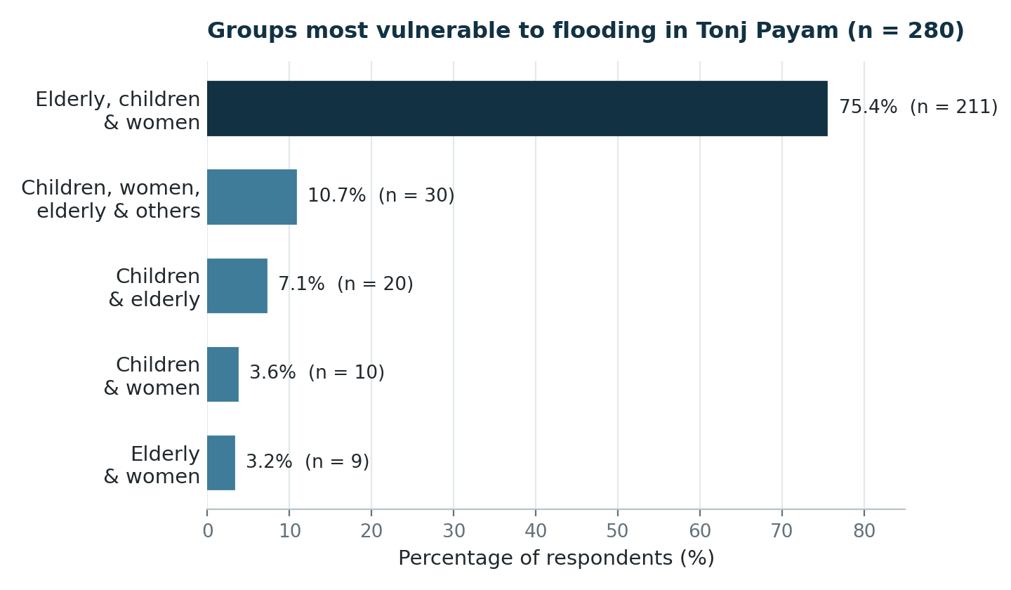
Respondents were asked which groups they considered most affected by flooding. The elderly, children, and women were identified as the most vulnerable combination by three-quarters of respondents (75.4%). A further 10.7% considered children, women, the elderly, and other household members collectively vulnerable, while smaller proportions identified narrower combinations: children and the elderly (7.1%), children and women (3.6%), and the elderly and women (3.2%) (Figure 2). These findings are consistent with the wider disaster literature, which repeatedly identifies elderly people, children, and people with disabilities as disproportionately vulnerable because of intersecting physical and social disadvantages (Kuran et al., 2020).
Areas and facilities most affected by flooding
Homes and farmlands were the combination most frequently identified as affected by flooding (40.4%), closely followed by homes together with schools, markets, and health facilities (37.5%). A further 16.1% of respondents identified homes and cattle camps as affected, while 6.1% identified homes and roads specifically (Table 8).
| Facility/area affected | n | % |
|---|---|---|
| Homes and roads | 17 | 6.1 |
| Homes, schools, markets, and health facilities | 105 | 37.5 |
| Homes and farmlands | 113 | 40.4 |
| Homes and cattle camps | 45 | 16.1 |
Discussion
Demographic profile and its implications
Male respondents outnumbered female respondents by roughly three to two, which is consistent with the tendency for men to represent their households in community surveys of this kind in South Sudan, where men are more commonly recognised as household heads. Most respondents were of productive working age (26–45 years), the group typically most exposed to flood-related disruption of farming, business, and wage labour; a comparable pattern was documented among flood-affected households in Makurdi, Nigeria, where the working-age population bore a disproportionate share of the socio-economic burden of flooding (Ikyapa et al., 2022). The very high proportion of respondents with no formal education (77.5%) helps explain why the questionnaire was administered face to face rather than self-completed, and points to a wider need for flood-risk communication in Tonj Payam to rely on oral and visual channels rather than written material.
Causes of flooding
Respondents overwhelmingly attributed flooding to the natural overflow of the Tonj River and to the unculverted road built by AYAT Company, which blocks the natural flow of water across the floodplain. This finding illustrates how infrastructure built without adequate drainage provision can compound a naturally occurring hazard: a road without culverts does not cause rainfall, but it can turn a seasonal overflow into prolonged, localised waterlogging by obstructing the paths water would otherwise take. This finding underscores the importance of incorporating hydrological assessments into road design in flood-prone areas, rather than treating drainage as an afterthought.
Social and economic impacts
The near-universal agreement that flooding caused loss of life, property damage, and destruction of homes underscores the scale of harm experienced in Tonj Payam. Elderly people, children, and people with disabilities were repeatedly identified as least able to move safely through floodwater, reflecting the intersecting physical and social disadvantages documented in the wider vulnerability literature (Kuran et al., 2020). Economically, the disruption of transportation routes drove up the price of goods and the cost of moving property, consistent with evidence that local flooding can trigger disproportionately large, cascading failures across road networks well beyond the immediate area of inundation (Wang et al., 2019).
Environmental and health impacts
The reported loss of soil fertility, vegetation cover, and wider ecosystem function reflects processes documented elsewhere in the flood literature: prolonged inundation strips topsoil, deposits silt over productive land, and can facilitate the spread of invasive species, all of which degrade land productivity long after floodwaters recede (Raphela & Matsididi, 2025). The strong association between flooding and disease outbreaks and water pollution mirrors findings from other flood-prone urban and peri-urban settings in West Africa, where floodwater routinely contaminates drinking-water sources and precipitates outbreaks of waterborne illness (Songsore et al., 2006; Sam, 2009), and is consistent with the broader Nigerian evidence linking flooding to elevated rates of malaria and diarrhoeal disease through contaminated water and expanded mosquito breeding sites (Ikyapa et al., 2022).
Coping mechanisms, displacement, and government response
The coping mechanisms most strongly endorsed by respondents constructing culverts, raising compound levels, and de-silting riverbanksare low-cost, community-level adaptations rather than structural flood-control measures such as dykes or permanent relocation, which received far less support as measures already undertaken. This gap between what communities have done and what more durable flood management would require points to a continuing need for government and humanitarian investment in structural mitigation. During focus group discussions, participants in Thiet and Mabior Yar described markets as barely functional during flood periods, with limited goods reaching the area and prices rising sharply as a result, a pattern consistent with humanitarian monitoring of market access disruption across Warrap State during periods of flooding (REACH Initiative, 2021).
Conclusion
This study set out to assess the causes of flooding in Tonj Payam and its impacts on livelihoods and environmental sustainability, the coping mechanisms adopted by communities and government, and the groups most affected. The evidence points clearly to two dominant, and partly compounding, causes: the natural overflow of the Tonj River during the rainy season and an unpaved road that obstructs natural drainage. Flooding was found to inflict extensive social, economic, environmental, and health harm, including loss of life and property, disrupted trade, degraded soil and ecosystems, and outbreaks of waterborne disease. Elderly people, children, and women were consistently identified as the groups least able to cope with, or move safely away from, flood events.
Community-level coping mechanisms, while valuable, remain modest in scale relative to the extent of the problem: culvert construction, soil-topping, and de-silting are useful stopgaps, but they are not a substitute for structural flood management. On this basis, the paper recommends that:
- government and development partners support the relocation of the most flood-exposed households to higher ground on a voluntary, well-planned basis, with attention to land rights and access to livelihoods at the new site;
- culverts be retrofitted into the AYAT road and incorporated as a standard requirement in future road design in flood-prone parts of Warrap State;
- drainage canals and de-silting works along the Tonj River be expanded and formally maintained, building on the informal measures communities have already adopted; and
- local authorities enforce spatial planning and zoning rules that prevent encroachment on wetlands and natural drainage channels, which currently impede the natural passage of floodwater.
Future research building on this study should apply inferential statistical methods to test which demographic and livelihood characteristics most strongly predict flood vulnerability, and should validate community-reported flood timing and severity against hydrological or remote-sensing data, as set out under Limitations above.
References
Rights and permissions

Disclaimer
All claims expressed in this article are solely those of the author and do not necessarily represent those of the publisher, editors, reviewers, or affiliated institutions. Any product, service, or claim that may be evaluated in this article is not guaranteed or endorsed by the publisher.
Publisher’s note
The publisher remains neutral with regard to jurisdictional claims.
Additional information
Data availability
The data supporting the findings of this study are available from the corresponding author upon reasonable request.
Funding
Ethics declarations
Conflict of interest
The authors declare that they have no competing interests.
Article Timeline
Cite this article
- Received
- August 29, 2026
- Revised
- September 15, 2026
- Accepted
- September 28, 2026
- Published
- October 7, 2026
- Version of record
- October 7, 2026
Share this article
Share the article record with colleagues and readers worldwide.
Explore research across our journalsDiscover more research

Recent Publications
- Climate Information Sources, Adaptation Practices and Barriers among Smallholder Crop Farmers in Kakamega East Sub-County, Kenya
- Impacts of Climate Hazards, Vulnerabilities, and Adaptation Strategies of Banana Producers in Senegal: A Scoping Review
- Strengthening Carbon Fund Frameworks to Enhance Climate Sustainability Practice in Rural African Communities

Most Read

Recommended
- Impacts of Climate Hazards, Vulnerabilities, and Adaptation Strategies of Banana Producers in Senegal: A Scoping Review
- Strengthening Carbon Fund Frameworks to Enhance Climate Sustainability Practice in Rural African Communities
- The Role of Religious and Traditional Systems in Environmental Governance in Ukara Island, Tanzania
Save this article as a bookmark
Use your browser’s secure bookmark shortcut. Both desktop options are shown below.
Press Ctrl+D
In Chrome, Edge or Firefox, choose a folder if needed, then select Done.
Press ⌘ Command+D
In Safari, Chrome or Firefox, choose the bookmark location and confirm.
Cite this article
Copy a formatted citation or download a reference file.
Cited by
Crossref citation count for this DOI.