

Lithological Controls on Groundwater Recharge, Storage and Catchment Hydrology in East Africa: A Scoping Review

Abstract
Rock type, weathering and structure determine where water is stored and how quickly it moves through a catchment, yet the evidence linking lithology to hydrological behaviour in East Africa has not been mapped. This article reports a scoping review, structured by PRISMA-ScR and the Joanna Briggs Institute framework, of sources that relate lithological or structural properties to groundwater recharge, aquifer storage, borehole yield or streamflow, with emphasis on East Africa. Nineteen sources published between 1992 and 2022 were charted: fifteen from Africa and four comparators from outside the continent. Nine African sources concern crystalline and metasedimentary basement, two concern volcanic terrain in Ethiopia and four are pan-African syntheses. The charted evidence indicates that the weathering profile, rather than parent rock alone, controls storage and transmissivity in basement aquifers; that recharge in tropical Africa is episodic and tied to rainfall intensity; that high-yielding abstraction depends on thick regolith or superficial sediments; and that faults and lithological contrasts organise flow in volcanic rift terrain. Direct tests of lithological control on streamflow come almost entirely from temperate and montane catchments. No charted African source compares streamflow generation across contrasting lithologies within one catchment, and none measures rock moisture in tropical regolith. The article proposes a research agenda based on regolith characterisation, paired hydrometric monitoring, lithology-aware catchment models and long-term piezometry, and considers its relevance for south-western Uganda. Because the search was not run in subscription bibliographic databases, the charted set should be read as a core rather than exhaustive body of evidence.
Highlights
- ObjectiveNo reliable short passage identified. Please consult the full article. Read full text
- MethodsThe review followed the five-stage framework of Arksey and O’Malley (2005) as refined by Levac et al. (2010) and the Joanna Briggs Institute guidance (Peters et al., 2020). Read source
- FindingsThe evidence is concentrated on crystalline and metasedimentary basement, which accounts for nine of the 15 African sources (Figure 1a). Read source
- ConclusionThe Rwizi catchment covers about 8,000 km2 across ten districts of south-western Uganda and has experienced frequent water shortages, especially in the dry season (Songa et al., 2015). Read source
About this reading aid
These are complete passages selected automatically from the abstract and full text using section labels and study-specific wording. Selection runs locally on the journal server, without an external AI service. It may miss nuance or select an imperfect passage; it is not an independent assessment or an editor-reviewed summary. Missing points are identified explicitly.
Introduction
Rock type, the degree of weathering and the fracture network determine how much water a landscape can store, how fast it moves and where it re-emerges. In sub-Saharan Africa these properties have direct consequences for water supply. Weathered crystalline bedrock underlies about 40 per cent of the region and supplies water to more than a quarter of a billion people (Maurice et al., 2019). At continental scale, groundwater storage has been estimated at 0.66 million km3, more than 100 times annual renewable freshwater, with the largest volumes held in the sedimentary aquifers of North Africa (MacDonald et al., 2012).
Recharge, the process that renews these stores, also depends on the ground. A compilation of 134 ground-based estimates has been used to map recharge across the continent (MacDonald et al., 2021), and long-term observations show that its response to climate variability depends on aridity and local hydrogeology (Cuthbert et al., 2019). In East Africa, recharge has been linked to heavy rainfall (Owor et al., 2009; Taylor et al., 2013; Jasechko & Taylor, 2015). These findings concern groundwater. Work that treats lithology as a control on the whole catchment, including storage, baseflow and release, has advanced mainly in temperate and montane settings (Tague & Grant, 2004; Pfister et al., 2017; Carlier et al., 2018; Rempe & Dietrich, 2018). The resulting body of knowledge is rich in places and thin in others, and it has not been mapped across lithological classes and hydrological variables.
A scoping review suits this problem because it charts the extent and character of evidence rather than pooling effect sizes (Arksey & O’Malley, 2005; Tricco et al., 2018). This article addressed three questions. First, which lithological settings, regions and hydrological variables does the East African evidence cover? Second, which lithological and structural controls are reported, and with what magnitudes? Third, which gaps limit catchment-scale prediction? The article closes with implications for south-western Uganda.
Methods
Review Design and Reporting
The review followed the five-stage framework of Arksey and O’Malley (2005) as refined by Levac et al. (2010) and the Joanna Briggs Institute guidance (Peters et al., 2020). It is reported against the PRISMA extension for scoping reviews (Tricco et al., 2018). A protocol was not registered in advance.
Eligibility Criteria
Eligibility was defined using the Population–Concept–Context structure recommended for scoping reviews (Table 1). A source was included when it reported field, modelling or synthesis evidence relating a lithological or structural property to recharge, storage, transmissivity, yield, baseflow or streamflow. Four sources from outside Africa were retained as comparators because they test lithological control on streamflow or storage directly and no African equivalent was identified.
| Element | Criterion |
|---|---|
| Population | Hydrological systems (aquifers, wellfields, catchments) for which rock properties are described |
| Concept | Lithological, weathering or structural control on recharge, storage, transmissivity, yield, baseflow or streamflow |
| Context | Africa, with emphasis on East Africa and Uganda; non-African catchment studies retained as comparators |
| Source types | Peer-reviewed articles and reviews in English reporting field, modelling or synthesis evidence |
| Exclusions | Studies of water quality or geochemistry without a hydrological variable; sources with no lithological or structural description |
Note. Structure follows Peters et al. (2020). No lower date limit was applied; searches ran to 3 November 2026.
Search and Selection
Searches were run on 3 November 2026 in a general scholarly web index and in open repositories, including publisher platforms and institutional archives. Search terms combined lithological terms (weathered basement, crystalline, volcanic, regolith, saprolite), hydrological terms (recharge, transmissivity, baseflow, streamflow, yield) and regional terms (East Africa, Uganda, Tanzania, Ethiopia, Rwizi). Titles and abstracts were screened against Table 1, full texts or abstracts were checked for eligible items, and the reference lists of retrieved reviews were consulted for further sources. Screening was carried out by one reviewer. The search was not run in subscription bibliographic databases, so record counts at each stage are not reported (see Scope and Limitations).
Data Charting and Synthesis
For each source the author charted country, lithological setting, primary hydrological variable, study design and principal findings. Categories were assigned from each source’s own description of its setting and then tallied. As is usual in scoping reviews, study quality was not formally appraised (Tricco et al., 2018). Findings were synthesised narratively around the controls identified, and quantitative values are given as stated in the sources.
Results and Discussion
Characteristics of the Evidence Base
Nineteen sources were charted (Table 2). They span 1992 to 2022, and eleven were published in 2015 or later. Fifteen concern Africa and four are non-African comparators. Six of the African sources are specific to Uganda, two to Ethiopia and seven span several countries or the continent (Figure 1b). No retained source is specific to Kenya, Tanzania or Rwanda, and Tanzanian evidence appears only within multi-country studies.
The evidence is concentrated on crystalline and metasedimentary basement, which accounts for nine of the 15 African sources (Figure 1a). Aquifer storage, transmissivity and flow is the most common primary variable, with eight sources, followed by recharge and by streamflow and surface-water exchange, with five sources each. Borehole yield and abstraction is the focus of one source. Within Africa, streamflow and surface-water exchange is the primary variable in only two sources, and one of these is a catchment risk assessment rather than a test of lithological control. All three sources that test bedrock control on streamflow directly lie outside Africa.
| Source | Region | Lithological setting | Primary focus |
|---|---|---|---|
| Howard et al. (1992) | Uganda | Crystalline basement | Fracture permeability |
| Taylor & Howard (2000) | Uganda | Weathered crystalline rock | Tectono-geomorphic model of hydrogeology |
| Ayenew (2001) | Ethiopia | Volcanic (Main Ethiopian Rift) | Numerical groundwater flow, rift lakes basin |
| Tague & Grant (2004) | Oregon, USA | Volcanic (Cascades) | Low-flow regimes |
| Owor et al. (2009) | Uganda | Weathered basement | Rainfall intensity and recharge |
| Owor et al. (2011) | Uganda | Weathered basement | Groundwater–lake interactions |
| MacDonald et al. (2012) | Africa | Multiple | Maps of storage and yield |
| Taylor et al. (2013) | East Africa | Weathered basement | Recharge and extreme rainfall |
| Azagegn et al. (2015) | Ethiopia | Volcanic | Interbasin groundwater transfer |
| Jasechko & Taylor (2015) | Tropics | Multiple | Intensive rainfall and recharge |
| Songa et al. (2015) | Uganda | Basement terrain* | Catchment water risk |
| Pfister et al. (2017) | Luxembourg | Contrasting bedrock | Storage, mixing and release |
| Carlier et al. (2018) | Europe | Contrasting bedrock | Streamflow dynamics |
| Rempe & Dietrich (2018) | California, USA | Weathered bedrock | Rock moisture |
| Cuthbert et al. (2019) | Sub-Saharan Africa | Multiple | Resilience of groundwater to climate |
| Maurice et al. (2019) | Uganda, Tanzania | Weathered basement | High-intensity abstraction |
| Lachassagne et al. (2021) | Global, incl. Africa | Hard rock | Weathered aquifer guidelines |
| MacDonald et al. (2021) | Africa | Multiple | Maps of recharge |
| Nyenje et al. (2022) | Uganda | Weathered basement | Urban aquifer and springs, Kampala |
Note. Settings are as described by each source where available. Classes used for Figure 1 were assigned by the author. *Classified as basement by the author because the source refers only to the geology of the area.
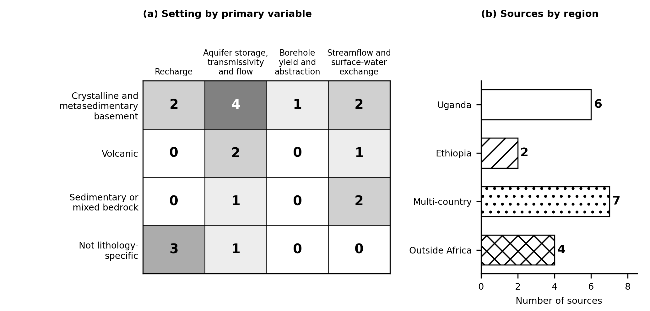
Note. Panel (a) counts sources by lithological setting and primary hydrological variable. Panel (b) counts sources by region. Each source is counted once.
The Weathering Profile as the Primary Control in Basement Terrain
The basement literature converges on the weathering profile, rather than the parent rock, as the unit that controls storage and flow. In Uganda, early work on fracture permeability and a later tectono-geomorphic model tied hydraulic properties to deeply weathered profiles on ancient erosion surfaces (Howard et al., 1992; Taylor & Howard, 2000). The review by Lachassagne et al. (2021) generalises the point, reporting that the hydraulic properties of hard-rock aquifers are produced by weathering and develop within roughly the upper 100 m. Figure 2 summarises this structure. Clay-rich saprolite stores water but transmits it poorly, the underlying saprock and fissured layer carries most of the flow, and fresh bedrock beneath is largely impermeable.
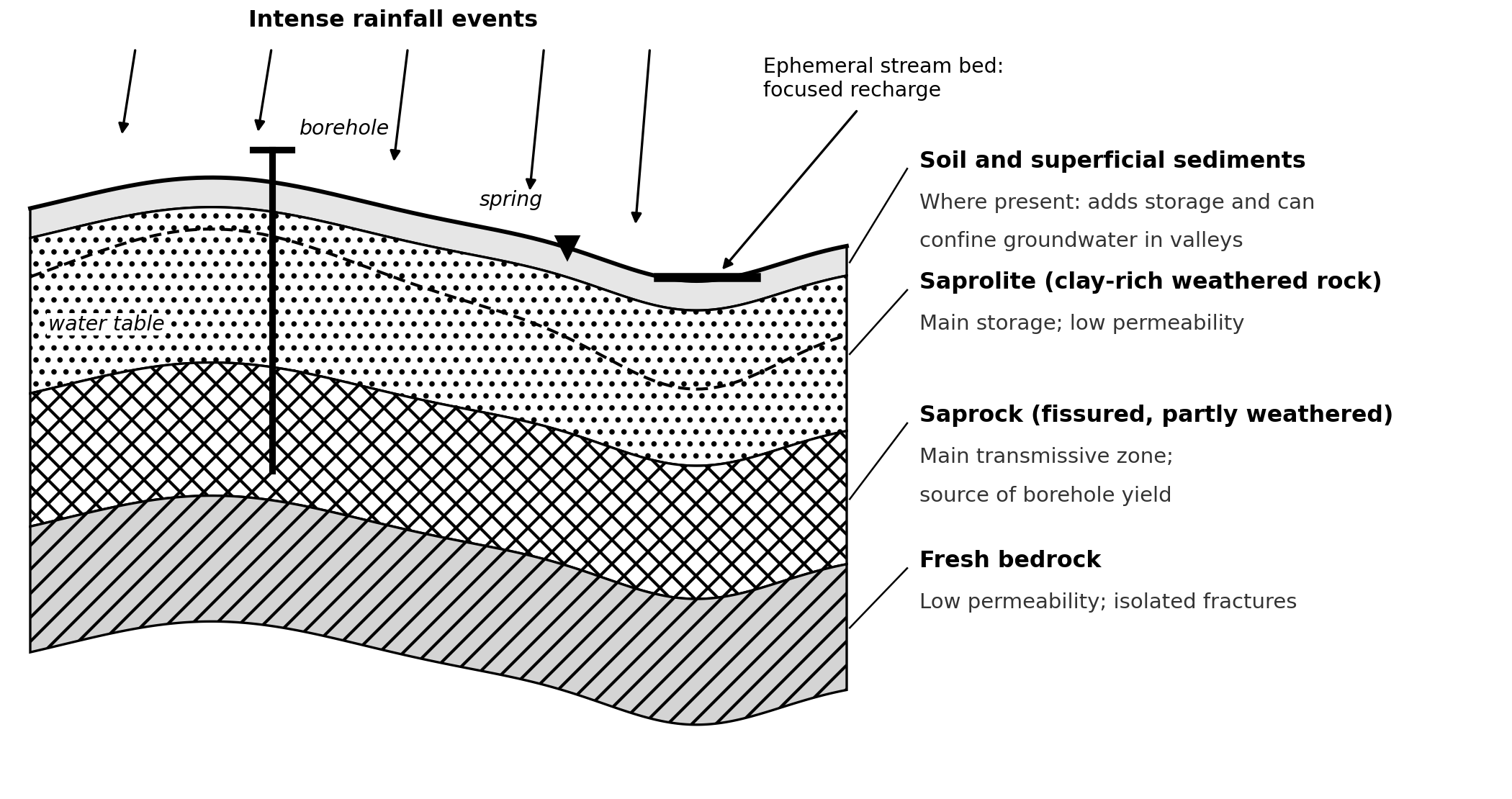
Note. Not to scale. Synthesised from the charted sources, including Lachassagne et al. (2021), Maurice et al. (2019) and Nyenje et al. (2022). Hydraulic properties develop within roughly the upper 100 m, and the weathered profile was 20–50 m thick at Kampala.
Field evidence from Kampala illustrates the pattern. The weathered profile was 20–50 m thick, the deeper system in the saprolite and saprock had transmissivity below 1 × 10⁻⁵ m2 s−1 and residence times of 40–60 years, and springs on valley slopes discharged shallower water younger than 30 years (Nyenje et al., 2022). Transmissivity in typical weathered basement aquifers is below about 10 m2 per day, with storage of 1–2 per cent (Maurice et al., 2019). These values are consistent with low-intensity abstraction being widely sustainable while high yields remain exceptional.
Recharge: Intensity, Pathways and Lithological Mediation
Recharge evidence from East Africa points to episodic, intensity-driven renewal. Rainfall and groundwater levels monitored at four stations in the Upper Nile Basin of Uganda during 1999–2008 led Owor et al. (2009) to conclude that rainfall intensification in the tropics may promote rather than restrict recharge. Longer records from Tanzania linked recharge to extreme seasonal rainfall associated with El Niño (Taylor et al., 2013), and a tropics-wide isotopic analysis reached a similar conclusion (Jasechko & Taylor, 2015). At continental scale, Cuthbert et al. (2019) found that aridity governs the dominant recharge processes and that local hydrogeology influences how sensitive recharge is to climate variability. In Niger and central Tanzania, ephemeral streams have been shown to provide preferential recharge pathways through the saprolite (Taylor et al., 2019).
Lithology therefore enters these accounts as a mediator of the rainfall signal. Regolith thickness, clay content and the presence of ephemeral stream beds help determine whether intense rainfall reaches the saturated zone. The Kampala study reported recharge of 3–50 mm per year, slow and prolonged to the deep system and quick and episodic to valley springs (Nyenje et al., 2022). A range of this width is what regolith-mediated recharge would be expected to produce, and it implies that single recharge values transferred between basement sites carry large uncertainty.
Storage, Yield and Abstraction
High-yielding abstraction from basement aquifers is possible but depends on setting. Five intensively pumped sites in Uganda and Tanzania, each with multiple boreholes yielding several litres per second or more, drew on weathered basement, and at four of them younger superficial sediments overlay the regolith and added storage (Maurice et al., 2019). Groundwater at these sites combined recent recharge, 10–60 years old, with water recharged over several decades. That mixture suggests some resilience to short droughts but leaves long-term sustainability uncertain, and multi-decadal piezometry at Makutapora in Tanzania shows the kind of record needed to resolve it (Maurice et al., 2019). Table 3 collects the quantitative evidence reported in the charted sources.
| Setting | Reported evidence | Source |
|---|---|---|
| Weathered basement, East Africa | Transmissivity typically below 10 m2 per day; storage 1–2% | Maurice et al. (2019) |
| Kampala, Uganda | Weathered profile 20–50 m thick; recharge 3–50 mm per year; deep-system transmissivity below 1 × 10⁻⁵ m2 s−1; residence times 40–60 years (deep) and under 30 years (springs) | Nyenje et al. (2022) |
| Intensively pumped sites, Uganda and Tanzania | Boreholes yielding several L s−1 or more; superficial sediments over regolith at four of five sites; groundwater partly 10–60 years old | Maurice et al. (2019) |
| Upper Nile Basin, Uganda | Four combined rainfall–groundwater stations, 1999–2008; recharge related to rainfall intensity | Owor et al. (2009) |
| Africa, storage | 0.66 million km3 (range 0.36–1.75 million km3), more than 100 times annual renewable freshwater | MacDonald et al. (2012) |
| Africa, recharge | 134 ground-based estimates, 1970–2019, used to map recharge | MacDonald et al. (2021) |
| Hard-rock aquifers, global | Hydraulic properties developed within roughly the upper 100 m | Lachassagne et al. (2021) |
| Northern California (comparator) | Rock moisture up to about 27% of annual precipitation | Rempe & Dietrich (2018) |
Note. Values are reported as stated in the sources. The Northern California value is outside Africa and is shown for contrast.
Volcanic Rift Terrain: Structure and Lithological Contrast
The Ethiopian studies show a different organising principle. In the central Main Ethiopian Rift, numerical modelling indicated that faults exert a first-order control on groundwater flow between lake sub-basins (Ayenew, 2001). South of the Blue Nile, a litho-structural framework reconstructed from stratigraphy and regional fault systems controls the size of recharge areas and the distribution of aquifers and aquicludes, and a significant proportion of groundwater recharged in the Muger and Jema sub-basins contributes to storage in the Upper Awash basin (Azagegn et al., 2015). In such terrain, topographic catchment boundaries are unreliable guides to water budgets, and structure must be mapped alongside lithology.
Catchment-Scale Lithological Control: Evidence from Outside Africa and the African Gap
Direct tests of lithological control on streamflow are concentrated outside Africa. Tague and Grant (2004) showed that contrasting volcanic units in the Oregon Cascades produce distinct low-flow regimes. Pfister et al. (2017) found that catchment storage, mixing and release varied with bedrock geology across 16 nested catchments in Luxembourg, and Carlier et al. (2018) concluded that geology controls streamflow dynamics. Rempe and Dietrich (2018) measured rock moisture in weathered bedrock in northern California and found it could hold up to about 27 per cent of annual precipitation, a store that conventional soil-moisture and groundwater monitoring would miss.
The African equivalent is thin. Owor et al. (2011) documented groundwater–lake interactions on weathered surfaces of low relief around Lakes Victoria and Kyoga. Songa et al. (2015) reported that groundwater in the Rwizi catchment is highly variable and generally poor because of the geology, but their catchment risk assessment was not designed to test lithological control on flow. No charted African source compares streamflow generation, baseflow or storage across contrasting lithologies within a catchment, and none measures rock moisture in tropical regolith. Both gaps matter. Tropical weathering profiles are thick, and storage in the unsaturated regolith may be large relative to the groundwater stores that have been measured.
Lithological Controls on Groundwater Recharge, Storage and Catchment Hydrology in East Africa: A Scoping Review
Cross-Cutting Synthesis
Three patterns recur across the lithological classes (Table 4). First, storage and transmissivity are decoupled in weathered terrain. Saprolite stores water but transmits it poorly, whereas the saprock transmits water but holds less of it (Lachassagne et al., 2021; Nyenje et al., 2022). Second, structure and superficial cover modify the profile. Clay-rich valley alluvium confined groundwater at Kampala (Nyenje et al., 2022), superficial sediments added storage at pumped sites (Maurice et al., 2019), and faults and horsts organised flow in volcanic terrain (Ayenew, 2001; Azagegn et al., 2015). Third, recharge is focused and not diffuse, following heavy rainfall, ephemeral stream beds and valley springs (Owor et al., 2009; Taylor et al., 2013; Taylor et al., 2019; Nyenje et al., 2022). Together these patterns imply that a single lumped storage parameter is inadequate for most of the terrain charted here, and that yield prediction needs mapped regolith and cover.
| Setting | Dominant control reported | Hydrological consequence | Sources (n) |
|---|---|---|---|
| Crystalline and metasedimentary basement | Thickness and structure of the weathering profile (saprolite, saprock); superficial sediments | Low transmissivity and storage in typical profiles; episodic, focused recharge; high yields only where regolith or cover is thick | 9 |
| Volcanic terrain | Faults, horsts and contrasts between volcanic units and aquicludes | Flow organised by structure; interbasin transfer; distinct low-flow regimes | 3 (2 African) |
| Sedimentary or mixed bedrock | Contrasts between bedrock units; moisture held in weathered bedrock | Differences in catchment storage, mixing and release; rock moisture | 3 (none African) |
| Syntheses not specific to lithology | Aridity and local hydrogeology | Recharge tied to rainfall intensity; resilience of groundwater to climate variability | 4 |
Note. Author’s synthesis of the charted sources. Source counts follow Figure 1a.
Implications for South-Western Uganda and a Research Agenda
The Rwizi catchment covers about 8,000 km2 across ten districts of south-western Uganda and has experienced frequent water shortages, especially in the dry season (Songa et al., 2015). The review points to four priorities for basement catchments of this kind. The first is regolith characterisation: mapping weathering-profile thickness and clay content, since profile thickness is the best-supported control on storage and yield (Lachassagne et al., 2021; Nyenje et al., 2022). The second is paired monitoring of rainfall, groundwater level and streamflow at the same sites, the design that made the Upper Nile Basin record informative (Owor et al., 2009). The third is lithology-aware catchment modelling, in which storage parameters are tied to mapped regolith and bedrock units instead of being calibrated as lumped values. The fourth is long-term piezometry and abstraction records, because residence times and decadal variability in recharge determine whether intensive abstraction can be sustained (Maurice et al., 2019).
For water supply planning, the same evidence argues for siting by setting. At Kampala, small-scale abstraction was judged more sustainable in the deeper system of the valleys, where confined conditions occur, than in the shallow system that feeds springs (Nyenje et al., 2022). Intensive abstraction requires thick regolith or superficial cover and a multi-decadal groundwater-level record before long-term yield can be assumed (Maurice et al., 2019). Continental recharge maps (MacDonald et al., 2021) and storage maps (MacDonald et al., 2012) are valuable for screening, but the charted evidence shows that local weathering and cover can change outcomes within short distances, so site investigation remains necessary.
Scope and Limitations
The search was run in a general scholarly web index and open repositories rather than in subscription bibliographic databases, and screening was done by a single reviewer. The 19 charted sources are therefore a core set and not an exhaustive census, and no record counts are reported. Grey literature, including national geological survey reports and theses, was not searched systematically and may hold relevant data. Only English-language sources were considered. Category assignments reflect the author’s reading of each source, and some sources span categories, so the counts indicate emphasis and not exact coverage. Quantitative values are reported as published and were not re-derived. The absence of African catchment-scale lithology studies in this set may partly reflect search coverage and should be tested in a database-based update.
Conclusion
This scoping review charted 19 sources on lithological control of recharge, storage, yield and streamflow, with emphasis on East Africa. The evidence supports four conclusions. The weathering profile is the main control on storage and transmissivity in basement aquifers. Recharge is episodic and intensity-driven, with regolith and stream beds mediating the rainfall signal. High yields require thick regolith or superficial sediments. Faults and lithological contrasts organise flow in volcanic rifts. The main gap lies at catchment scale, where African tests of lithological control on streamflow, baseflow and rock moisture are missing. Closing that gap through regolith mapping, paired hydrometric monitoring, lithology-aware modelling and long-term piezometry would allow basement catchments such as the Rwizi to be managed on the basis of measured storage and flow.
References
Rights and permissions

Disclaimer
All claims expressed in this article are solely those of the author and do not necessarily represent those of the publisher, editors, reviewers, or affiliated institutions. Any product, service, or claim that may be evaluated in this article is not guaranteed or endorsed by the publisher.
Publisher’s note
The publisher remains neutral with regard to jurisdictional claims.
Declarations & editorial transparency
Data availability
Data availability is not applicable to this article because no new data were created or analysed.
Funding
This research received no specific grant from any funding agency in the public, commercial, or not-for-profit sectors.
Ethics declarations
Ethics approval was not required for this study.
Peer review statement HRL Journal Service Policy
HRL Journal Service uses the following process for manuscripts sent for external peer review. An associate editor screens scope and eligibility; an academic editor assesses subject relevance and scholarly quality. The Editor-in-Chief and academic editor appoint suitable reviewers and manage conflicts of interest. Review is double blind: author and reviewer identities are concealed from one another during review. Authors respond to the feedback, with further review where needed. Once satisfied with the revisions, the academic editor recommends approval and forwards the manuscript for copyediting, reference checks and correction of typographical errors. The Editor-in-Chief makes the final publication decision. Article-specific review records and any exceptions are reported separately below.
Article-specific review status not recorded
Academic editor names are published according to the journal’s disclosure policy and the editor’s consent. An editor may request non-display; authors may raise a reasoned concern, which the journal assesses for privacy, safety and conflicts of interest. A missing name alone does not establish the reason for non-display or imply an ethics concern. Reviewer anonymity during double-blind review is a separate matter.
AI use & language assistance HRL Journal Service Policy
Authors and copyeditors may use language-assistance tools, including Grammarly, to improve spelling, grammar and readability under human supervision. Edits must preserve scientific meaning, uncertainty and the authors’ interpretation. Authors remain responsible for the accuracy, originality, references and integrity of their work; AI tools cannot qualify as authors or replace editorial judgement. Authors must disclose AI assistance at submission. Generative rewriting, content creation or use in research methods, analysis or figures requires an article-specific statement identifying the tool and its purpose; no use may fabricate data, sources or findings. Confidential manuscripts and personal data must not be shared with external tools without appropriate permission and confidentiality safeguards. This shared policy does not establish whether a tool was used in this article; any supplied article-specific disclosure appears below.
No separate AI-use disclosure has been supplied in this record. This does not establish that AI was or was not used.
Publication timeline
Recorded milestones for this article. Only supplied dates are shown.
- Received
- Revised
- Accepted
- Published
How the HRL review process works
The standard route for manuscripts sent for external peer review; this illustration does not certify individual stages or supply missing dates.
- 01Scope & eligibilityAssociate editor
- 02Subject assessmentAcademic editor
- 03Double-blind peer reviewReviewers appointed by the editorial team
- 04Revisions & academic approvalAuthors respond; academic editor evaluates
- 05Copyediting & reference checksCopyeditor
- 06Final publication decisionEditor-in-Chief
Cite this article
Share this article
Share the article record with colleagues and readers worldwide.
Explore research across our journalsDiscover more research

Recent Publications

Most Read

Recommended
Save this article as a bookmark
Use your browser’s secure bookmark shortcut. Both desktop options are shown below.
Press Ctrl+D
In Chrome, Edge or Firefox, choose a folder if needed, then select Done.
Press ⌘ Command+D
In Safari, Chrome or Firefox, choose the bookmark location and confirm.
Add to Mendeley
Save this article’s reference using either option below.
Import a reference file
Download the RIS file, then import it in Mendeley Reference Manager using Add new → Import library, or drag the file into your library.
Download RIS for MendeleyUse Mendeley Web Importer
With the extension installed, return to this article and select the Mendeley icon in your browser toolbar. Review the detected reference before saving.
Get the official Web ImporterYou choose what to import. Opening this dialog does not sign you in or send article content to Mendeley.
Cite this article
Copy a formatted citation or download a reference file.
Cited by
Crossref citation count for this DOI.